Monday, August 31, 2015

Entry - August 31, 1936

8.00 The Heavens Peak fire busted loose again. They called out all of us from our camp and all from eight more camps so that we had about sixteen hundred men. This is August the 31st and we are in camp for two hours for our pay and right back out on the fire again. I have been seeing so many fires lately that I am sick of them and sometimes I think that I will go nuts being around them so much.

The fire has burnt over about eight miles of the parks beautiful scenery before we got it under control. It burnt up all the many glacier chalets and the museum and some of the beautiful bridle paths were burnt up.

We came back in the camp today on the thirty first of August.


Robert

---------------------------------------------
Comments from Chris

Obviously, the fire wasn't as contained as Robert though in his previous post. Typically a fire as hot as this is going to have coals that smolder for days and can easily catch again. 

Rolf Larson has an excellent story about this fire based on multiple first hand accounts. You can read it here - http://www.glacierparkfoundation.org/History/firestorm.html

Today is the day the Many Glacier Hotel almost burnt to the ground. The story is documented in Rolf's link. I've also included a map of the area below. Take a look at how the high winds took this fire from Heaven's Peak down in to the Swiftcurrent Valley.

Ten days in to the fire now.


Heaven's Peak
From Robert's CCC Photo Collection

Heaven's Peak and Many Glacier Hotel
Robert's 1936 Glacier National Park Map
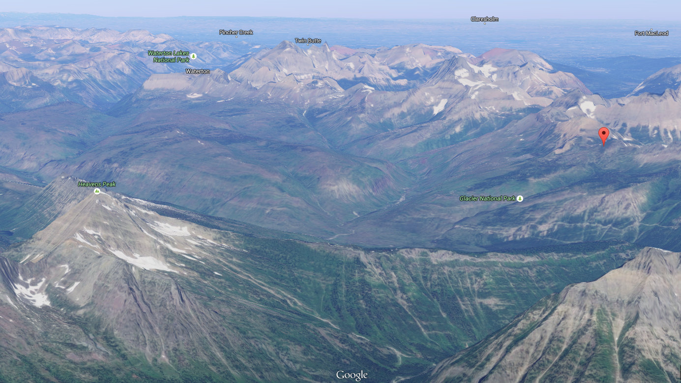
Heaven's Peak on left. Swiftcurrent Pass at orange marker
Google Maps
Swiftcurrent Pass looking in to Swiftcurrent Valley
Google Maps


Friday, August 28, 2015

Entry - August 28, 1936

9.00 P.M. All the fires seem to be out. They have had about 5,000 men working on twenty fires in the park. When you get near of a fire you see all the bear, deer, and birds leaving the territory.

Robert

--------------------------------------------
Comments from Chris

Seven days in to the fire.

A wildfire like this typically doesn't kill many animals. They know how to get out of the area. Some of the predators even know how to catch other animals when they are escaping. This must be quite a feeling when everything in the woods is heading one way and you are going the opposite. 

Deer Leaving Fire
Washington Post

Thursday, August 27, 2015

Entry - August 27, 1936

8:00 Am We reported to camp last night and they let us sleep for 5 hours and sent us up the road sixty miles to a place out side of the park called Winnoed Ridge where a thousand acres were burning and we worked there about twenty hours till we got that under control and then we went back to camp to see if there were any more fires to take care of. They told us to rest up and we were going to go out the next day maybe. I sure am one tired son-of-a-gun.

Robert

----------------------------------------------
Comments from Chris

Winona (Winnoed) Ridge is one of the places Robert marked on his map as you can see below. I love how this is called a ridge. This is almost as tall as Tennessee's highest point. 

This is turning out to be a very rough week. We're six days in now from when the electrical storm came though. That is a long time for the kind of hours they are putting in.

In doing the research for this blog, I've come across many interesting places. Take a look at these cabins at the North Fork Hostel & Inn. I'd like to go stay there for the next month and finish out these posts.


Winona Ridge from Demer's Ridge
Photo via North Fork Hostel & Inn

Winona Ridge checked on the left
Robert's 1936 Glacier National Park Map

Monday, August 24, 2015

Entry - August 24, 1936

8.00 PM This is August 24 and we just got back from a fire we went out on August 21st. It was on Heaven's Peak which is about 8000 ft high. It took us about 3 hours to get to the top and she sure was steep. After we reached it, it turned out to be a blazing hell and we could not even get near it without endangering our lives so we had to wait till night till it calmed down a bit and then we fought it for about twenty hours straight then we got relief by another crew. We went back up on the top after a rest of six hours and tackled it for another twelve hours and then we had it under control and then we were relieved again. We went back up on top again to patrol it for an eight hour shift to see that it didn’t jump the trail and after we were up there about three hours a string wind blew she jumped the trail and started to burn again. It blew the sparks over a five hundred foot cliff and they had to lower us by ropes to fight it. One fellow fell and was all banged up. I learned that he died today. We sure did have a hell of a time trying to put a forest fire out on the side of a eighty percent cliff. After our shift was over they pulled us back up to the top and we went back down the trail. When we got to the bottom of the mountain they told us to report to our home camp for another fire as big as that burning on our side of the lake.

Robert

-----------------------------------------------
Comments from Chris

If you remember at the beginning, Robert said he was writing this down to let his mother know of his adventures. What do you think she thought when she read this entry? What an amazing and dangerous few nights.

It turns out, this is one of the biggest and most destructive fires in Glacier National Park history. Thousands of acres and many structures will be destroyed. This will be driving Robert's activities for the next week.
Forest Fire
By (Photograph used by permission of the USDA Forest Service.) [CC BY 2.5 (http://creativecommons.org/licenses/by/2.5)], via Wikimedia Commons

Heaven's Peak
From Robert's CCC Photo Collection


Heaven's Peak
Photograph by Ryan McKee
d
Heaven's Peak in center towards top
Robert's 1936 Glacier National Park Map

Sunday, August 23, 2015

Supplemental

Several days have passed since the last post. From the last entry you may have guessed what happened. I think this may be the biggest gap in the journal and for good reason. Robert will be back to explain tomorrow.

In the meantime, I just wanted to take some time to gather feedback. Basically, how do you think its going? We're almost two months in to Robert's adventure now and have seen quite a few posts. 

Also, are there any topics you would like to see further explored in the weeks to come?

Chris

Thursday, August 20, 2015

Entry - August 20, 1936

9.00 PM We are grounded today. There was a big electrical storm and there is fires all over the park. We are expecting to go out on one at any minute of the night.

Robert

------------------------------------------------
Comments from Chris

Although Robert was worried about park visitors starting fires, lighting can be just as devastating. This is a bad time for it as well. You've already heard about how hot and dry Montana has been. These are prime fire conditions.


Lightning Over Lake McDonald
Unknown Photographer - Imgur

Wednesday, August 19, 2015

Entry - August 19, 1936

6.00 PM. Seen two mama bears and four cubs today out at the foot of Mt. Cannon today as we passed. One cub was a friendly little cuss. I fed him some bread and he didn’t seem a bit scared. I was.

Robert

-----------------------------------------------
Comments from Chris

General note: don't do this. 


I think we may be a bit over-sensitized to wild animals, but in general, you stay away from wild animal mama's and their children. Especially when they look like the photo below.

Robert marked the map by Mt. Cannon. I wonder if that is related to today's post.

Grizzly Bear
By Bauer, Erwin and Peggy, U.S. Fish and Wildlife Service [Public domain]
Robert's 1936 Glacier National Park Map

Tuesday, August 18, 2015

Entry - August 18, 1936

7.00 PM Worked up on Howe Ridge today cutting down burnt timber. It sure is a dirty job. Signed the payroll today. I am six bucks in the hole today. I sent nineteen of scenery pictures of mine home today.

Robert

------------------------------------------------------
Comments from Chris

In today's parks, opinions about cutting burnt timber have changed. Cutting the timber interrupts the natural healing process the forest goes through after a wildfire, so the remains are left standing. I saw this on a trip to Yellowstone a few years ago. I've included a picture below from that trip.


Moose on Howe Lake
From Robert's CCC Photo Collection

Burnt Trees at Yellowstone
Photo by Sean Fitzgerald

Monday, August 17, 2015

Entry - August 17, 1936

10.00 P.M. Went on a fire last night up on Snyder Ridge and we walked about 6 hours for nothing because the fire was out when we got there. I sure am tired today.

Robert

-----------------------------------------
Comments from Chris

Six hours was probably worth it to find no fire. As we've seen in the past, Snyder Ridge is across the lake from the camp. At the foot of the ridge, just beside the lake runs the Going-to-the-Sun Road. 

The Going-to-the-Sun Road is a key part of visiting the park as it is the only road you can cross the park on. It was completed in 1932, two years before Robert's time there.  At the time, It was significant in that it was one of the first national park projects to accommodate visitors traveling via automobile. 

The road is named for the Going-to-the-Sun Mountain by which the road passes on the eastern side of the park. This mountain is one of the many views on the road. You could look on about any list of the most beautiful drives in America and this road will be on it. You should plan to see it in the summer though as parts of it can get over a 100 feet of snow in the winter.

Going-to-the-Sun Mountain
Going-to-the-Sun Road
By Joeyp3413 (Own work) [CC BY-SA 3.0 (http://creativecommons.org/licenses/by-sa/3.0)]
Going-to-the-Sun Road With Receding Snow
By GlacierNPS (Coyote on Going-to-the-Sun Road) [CC BY 2.0 (http://creativecommons.org/licenses/by/2.0)], via Wikimedia Commons


Sunday, August 16, 2015

Entry - August 16, 1936

9.00 P.M. Today is Tubbys birthday. I’d remember that if I live a hundred.

Robert

-----------------------------------------
Comments from Chris

Tubby is Robert's older brother Paul. If Robert did live to a hundred, we could still ask him questions about his time here.


Robert sitting on tree
From Robert's CCC Photo Collection

Saturday, August 15, 2015

Entry - August 15, 1936

9.00 A.M. Today is Saturday so I think I will just laze around all day and go to town tonight.

Blondes

Brunetts

Red Heads

ay - ay - ay -


Robert

-----------------------------------------
Comments from Chris

Not sure where the poetry came from. It sounds like he is ready to go to town.


One of the camp tents
From Robert's CCC Photo Collection
August 15th entry from the journal
Robert's CCC Journal

Friday, August 14, 2015

Entry - August 14, 1936

8.00 P.M. What a day! I had to argue with every guy on my crew today to get them to work. I sent one in to the army and they sent him home. Had another fire today but I was lucky to get out of going. Mansfield went out on a lookout today to chase smoke.

Robert

-------------------------------------------
Comments from Chris

The army was ultimately in charge of the CCC and unlike the military, it was easy enough to kick people out. I wonder if the recent fire fighting has taken a toll on morale.

I thought this photo would go along with taking out some frustration. 

Robert smiling in the back row above the left boxers right glove
From Robert's CCC Photo Collection

Thursday, August 13, 2015

Entry - August 13, 1936

10.00 P.M. Rained again today thus reducing fire hazards. Expected to go to another fire today till it rained. I guess the lord is still thinking of us c.c.c. boys.

Samboy killed a bat today that was flying around in our tent.

In a womens eyes there lies and lies and lies and lies.


Robert

----------------------------------------
Comments from Chris


I take it Robert had some time on his hands today for the little bit of poetry. 

While reading this post I was thinking about how the weather makes such a difference in these fire fights. If I was there today, I would be regularly checking the weather map on my phone. The problem here is that it would be another decade before weather radar came about. In World War II radar operators noticed they could see precipitation while looking for aircraft. After the war, they spent investigating this further and developed it in to what we have today. I imagine wildfire fighters now eagerly keep an eye on it. 

One of the Camp Tents
From Robert's CCC Photo Collection


August 13th entry from the Journal
Robert's CCC Journal

Wednesday, August 12, 2015

Entry - August 12, 1936

8.00 P.M. We had a safety lecture tonight. The fire hazards were stressed important.

I read in the Chicago paper where two Sikeston women got killed in an automobile at Cairo by rolling down the Levee.


Robert

----------------------------------------------
Comments from Chris

Sikeston is a small town close to where Robert is from. I mentioned early on that the geography of Robert's home town Cairo is interesting. It is surrounded on all sides by levees to keep out the surrounding rivers. On the Ohio side the levee is a concrete wall. The rest of the sides are composed of a dirt hill with a road on top. When the water get's high, the town can literally be surrounded by water.

I know from experience you can roll a vehicle down the levee. This happened to a truck I was in during my first summer out of high school. Doesn't sound like the two women were lucky enough to walk away. 

Something to think about here is the flow of news from home to Robert. He was not using the internet to read news in near real time. He was getting letters from home and reading newspapers. Cairo is more than 350 miles from Chicago, so the news would have to be big for Robert to see much of it in the paper. St. Louis is closer, but how many of these papers did Robert have access to in a camp in Montana. 

It's one hot 1936 summer! Today the Texas record high temperature is set at 120 degrees. In the summer of 1936, thirteen state heat records will be set that still stand today. This dry hot weather is not good for fire prevention.

Here are the records:

State Record high Date
temperature
Arkansas 120 °F / 49 °C August 10, 1936
Indiana 116 °F / 47 °C July 14, 1936
Kansas 121 °F / 49 °C July 24, 1936
Louisiana 112 °F / 44 °C August 10, 1936
Maryland 109 °F / 43 °C July 10, 1936
Michigan 112 °F / 44 °C July 13, 1936
Nebraska 118 °F / 48 °C July 24, 1936
New Jersey 110 °F / 43 °C July 10, 1936
North Dakota 121 °F / 49 °C July 6, 1936
Pennsylvania 111 °F / 44 °C July 10, 1936
Texas 120 °F / 49 °C Aug. 12, 1936*
West Virginia 112 °F / 44 °C July 10, 1936
Wisconsin 114 °F / 46 °C July 13, 1936

* Tied on June 28, 1994

Tuesday, August 11, 2015

Entry - August 11, 1936

10.00 P.M. I went to church at 6.30 A.M. and served mass and also went to communion.

I am going up the sunset trail in the near future if I possibly can. They say that farther up the trail that the Blackfoot indian Res. is.


Robert

-----------------------------------------
Comments from Chris

I don't see the Sunset Trail on current maps, but the Blackfoot reservation is on the eastern side. It is quite a way from where Robert is. You can see it on the right side of the map below.

I mentioned the Blackfoot land was purchased in 1895. Not long before this there were rumors of gold in the area. It was those rumors that would lead to the US government to pressure the Blackfoot in to selling the land where it could be opened up to non-Indian mining interests.

An interesting part  of the sale is that the Blackfoot would retain all non-mineral rights to the land. The Blackfoot could still hunt and use the land. This has been a point of contention for years resulting in many court cases over the last century. One even as late as 2000 when two Blackfoot members where brought to court for killing two bighorn sheep in the park. The judge did not agree when they referenced the provision for hunting in the original agreement.   

Blackfoot Tipis (1910)

Robert's 1936 Glacier National Park Map

Monday, August 10, 2015

Entry - August 10, 1936

9.00 The Chaplin who is a Catholic priest came into camp tonight and heard confessions and is going to hold services in the library tomorrow morning at 6:30. I went to confession and expect to go to communion tomorrow.

Robert

-------------------------------------------
Comments from Chris

Early on I mentioned Robert was Catholic. Robert's grandfather immigrated to the United States in 1852 from Cork County Ireland. He brought with him a tradition of Irish Catholic faith and passed it down from one generation to the next. 

The Catholic church back at Robert's home in Cairo is still there as its been since 1894.  

St. Patrick's Church, Cairo, IL
Via Google Maps

Sunday, August 9, 2015

Entry - August 9, 1936

10.00 PM. I went into the town of Whitefish and went to church. We got there pretty late. There sure is a bunch of Catholics in that town. I got a little blue tonight because Sunday sure is dead around here.

Robert

----------------------------------------
Comments from Chris

Whitefish was only at about 700 people back then, but a little closer than Kalispell. You can see it on the map below. 

I found this recent picture of Whitefish. Something tells me this section is similar to how it was back then.

Downtown Whitefish, MT
"Downtown-whitefish-2006". Via Wikimedia Commons
Apgar to Whitefish
Robert's 1936 Glacier National Park Map

Saturday, August 8, 2015

Entry - August 8, 1936

6.30 P.M. Being that today is Saturday we cleaned out our tent today. I went into town today and had a pretty fair time. The certainly is some nice lookers in the town of Kalispell.

Robert 

---------------------------------------------
Comments from Chris

Kalispell only had a population of about 7,000 people at the time. Even then, the town was less than 50 years old. Kalispell was started in 1891 as a railroad town on the Great Northern Railway. You can probably imagine towns in the old western movies that sprung up along the rail lines. This one one of those.

Now it is more than 20,000 and is the largest city in northwest Montana. There are still many historic structures in Kalispell. If you are traveling through, take a look, maybe you can get a feel for what it was like when Robert was there. 


Kalispell, MT
By Tony Hisgett from Birmingham, UK (Kalispell  Uploaded by tm) [CC BY 2.0 (http://creativecommons.org/licenses/by/2.0)], via Wikimedia Commons
Kalispell looking toward Glacier National Park
By User: Dan Petesch (Own work) [CC BY-SA 3.0 (http://creativecommons.org/licenses/by-sa/3.0) or GFDL (http://www.gnu.org/copyleft/fdl.html)], via Wikimedia Commons


Friday, August 7, 2015

Entry - August 7, 1936

9.00 P.M. I moved up to the position of acting leader today and have 18 men under me on my crew. We are cutting timber in back of camp and are making pretty fair headway.

Robert 

---------------------------------------
Comments from Chris

Robert has mentioned being an old hand at some of the things they are doing. He was indeed. Remember at this point he was close to completing his third six month term in the CCC. The document is from earlier in the year when he was in Oregon, just before Glacier. Take a look at the enrollee numbers. Robert is lower than all the rest. Most by a good amount. Pretty good for a twenty year old. 


Thursday, August 6, 2015

Entry - August 6, 1936

8.00 P.M. Hooray! It rained hard last night and we didn’t have to go on the fire. They just sent out five smoke chasers this morning to look things over and they reported everything satisfactory and under control.

Robert

-------------------------------------------
Comments from Chris

That is a relief. Can you imagine what the guys were like when they started to hear the rain fall. You could probably hear some Hooray's in those tents.

I get the impression smoke chaser is kind of an older term. I looked to see if there was anything special about that term compared to a fire fighter, but there weren't many results.


August 6th entry from the journal
Robert's CCC Journal

Wednesday, August 5, 2015

Entry - August 5, 1936

8.00 PM There is another fire up on Snyder Ridge and all of our fire fighting crews are grounded. I am on the first crew that is to go out. They told us to get all of our equipment together and be ready to go at any time during the night.

Robert

---------------------------------------
Comments from Chris

Snyder Ridge is just across the lake from camp. Judging from the photo, heading up Snyder ridge would be a daunting task, especially when you know what awaits at the top.
Looking at Snyder Ridge from Lake McDonald
With permission from willurbanski on Flickr 


Tuesday, August 4, 2015

Entry - August 4, 1936

3.00 Not much happened today. Went down to Charles Russell’s old homestead. He is the famous painter. He painted Custer’s Last Stand and many other outstanding pictures. He lived about a half of a mile from camp and I seen the place where he got killed.

Robert

------------------------------------
Comments from Chris

Charles Russell was an artist known for painting scenes of the old American west. He lived from 1864 to 1926, most of which was spent in Montana. When Russell was 24, he spent time living with the Kainai Nation. This is probably why Russell's artwork had a unique quality of being from the perspective of the Indians. 

The painting Robert mentions is shown below. You can see it is from the Indian perspective. 

I'm not sure exactly where the Homestead was, but the is a museum in Great Falls.

Charles Russell's "Battle of Little Bighorn"
"Charles Marion Russell - The Custer Fight (1903)" by Charles Marion Russell - The Library of Congress. Licensed under Public Domain via Wikimedia Commons

Monday, August 3, 2015

Entry - August 3, 1936

7.00 Still on time off. (Forgot to mention in August 1st entry that the garden wall is forty miles from camp and on the way we went through Logan Pass and also seen Heaven’s Peak and 7 or eight mountains I’ve never seen before. Haystack Butte is another place I seen (7440).

We sure seen some wonderful scenery. 


Robert

------------------------------------------
Comments from Chris

You can see Heaven's Peak, Logan's Pass and the Garden Wall on the map below. Haystack Butte is close to the Garden Wall, but not on the map. In the photo of Haystack Butte below you can see the Going-to-the-sun Road cutting through the middle of the photo.


Garden Wall
From Robert's CCC Photo Collection
Haystack Butte to the right of center
By GlacierNPS (Haystack Creek  Uploaded by AlbertHerring) [CC BY 2.0 (http://creativecommons.org/licenses/by/2.0)]


Sunday, August 2, 2015

Entry - August 2, 1936

7.00 Had time off today for yesterdays work being on Sunday. Went out swimming in the lake all afternoon. We had a lecture today from a war veteran on the evils and horrors of war.


Robert

--------------------------------------
Comments from Chris

This was 18 years after World War I. The depression in the United States was part of a global economic depression. This caused many people in the world to question capitalism and some to propose moving to socialist and communist style governments. This was the case even in the US where some of Roosevelt's programs were opposed because they were considered socialistic.

In other parts of the world, governments were drastically changed. There was general unrest throughout the world. The US had its own problems at home and wasn't too involved in international issues. Hitler had come to power two years before this time and Japan had invaded Manchuria five years before. You could say there was a storm brewing which we know would come to the US five years later.

Knowing the history now, I would like to have heard what was said in the lecture.

(Note: I'm not sure why he said Sunday above, unless he wrote under the wrong date, the work was on Saturday)


 Back of  photo says "Looking across the lake from camp"
From Robert's CCC Photo Collection

Saturday, August 1, 2015

Entry - August 1, 1936

8.00 P.M. Went out on a reserve party today to find a tourist that was lost on the garden wall. We climbed up to the altitude of 8500 and combed the whole mtn. side and didn’t find a trace of him. I seen 13 mountain goats and sheep today up in the rocks at about 7,000.

We didn’t find a trace of the lost tourist. He is probably dead.


Robert


--------------------------------------------------------------------
Comments From Chris -

Hundreds of people have died in the parks recorded history (1913). There are a variety of reasons, but the top five in order are:

1. Drowning
2. Heart Attacks
3. Climbing Accidents
4. Vehicle Accidents
5. Falling while hiking

After reading some of these posts I can see how heart attacks could be a problem. Just today Robert climbed up to 8,500 ft., which is about 5,000 ft. higher than camp. That must have been strenuous.

Complete side note, but sign of the times. Today is the day Hitler opened the 1936 Olympics in Germany.


Back of photo says "fellows strung out down the garden wall looking for the lost guy"
From Robert's CCC Photo Collection

Garden Wall
By GlacierNPS (May 16, 2012  Uploaded by Hike395) [CC BY 2.0 (http://creativecommons.org/licenses/by/2.0)]
Garden Wall
From Google Maps

Mountain Goat
"Mountain Goat Mount Massive" by Darklich14 - Own work. Licensed under CC BY 3.0